A while back, a friend showed me an application they had started using called OwnTracks, which periodically sends location updates from your phone to your own server. I used to collect similar location data back in the day via Google Latitude, so the idea of self-hosting my own tracking history intrigued me. Fast forward a few months, and I finally got around to setting it up.
Shortly after, another friend decided to set it up as well and mentioned wanting to import their historical Google Timeline exports into it. I hadn’t even considered that, but I loved the idea of giving it a shot since I had years of location data sitting around. A day or two later, I had my data fully ingested and viewable in OwnTracks, dating all the way back to mid-2010.
The first hurdle I ran into was that iOS Google Maps exports use a different format than the Android versions, requiring me to patch the import script to handle the iOS payload. Using an LLM coding assistant, I threw some sample data at it, and it quickly generated everything OwnTracks needed to ingest the files.
However, I quickly discovered that Google Maps on iOS logs far less granular data than it does on Android. Thankfully, I still had my old Android phone from when Google originally moved Timeline data on-device. That phone contained my complete, detailed history from my Android years up until my switch to iPhone, so I dutifully ingested that data too.

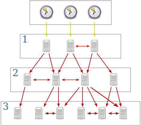
The lower the “Stratum” number the more accurate the time it should be able to tell. Usually Stratum 1 time servers are directly connected to an accurate source of time such as (but not limited to) Atomic, GPS or even Radio clocks. The stratum of the machine which itself is directly interfacing with the accurate time source would be “Stratum 0”. For each additional layer of NTP servers added, the stratum increases by 1.
I’ve been working on setting up a lab environment for myself and decided to pick up a couple of Ubiquiti’s